10 to 15 million people… Where did they go? Do you feel creepy…?
TL;DR
Using advanced LiDAR technology, researchers have discovered more than 60,000 previously hidden Maya structures in Guatemala’s Petén region, revealing a complex civilization with interconnected cities and extensive defensive systems. This groundbreaking find challenges the long-held belief that Maya cities were isolated, showing instead that they were connected by raised causeways that facilitated trade. The survey indicates the Maya population during the classical period could have been 10 to 15 million, far surpassing previous estimates. The discovery includes homes, defensive works, and even a seven-story pyramid that had been obscured by dense vegetation.
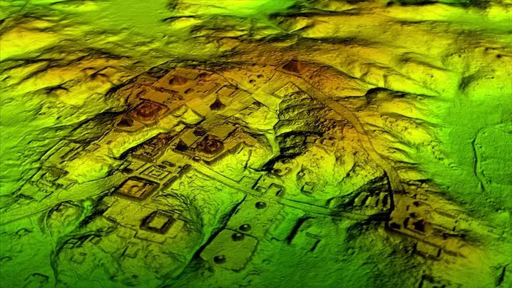
Using groundbreaking laser-mapping technology, researchers have made a significant archaeological discovery in Guatemala. According to Tom Clynes, who reported the findings in an exclusive for National Geographic, over 60,000 Maya structures—including homes, defensive works, and roads—were uncovered in the jungles of the Petén region, challenging what experts previously understood about the complexity and scale of the Maya civilization.
The discovery was made using Light Detection and Ranging, or LiDAR, which involves sending millions of laser pulses from an aircraft to the ground. By measuring the return of these pulses, detailed topographical maps are created. In Guatemala, LiDAR allowed researchers, with support from the PACUNAM Foundation, to map more than 800 square miles of terrain hidden beneath thick vegetation.
“I think this is one of the greatest advances in over 150 years of Maya archaeology,” said Brown University archaeologist Stephen Houston, who was part of the project, in an interview with the BBC.
Previously, researchers believed Maya cities were mainly isolated and self-contained. However, LiDAR scans reveal that Maya civilization was actually interconnected and sophisticated, much like the ancient civilizations of Greece and China. For instance, the team identified a network of broad, raised causeways connecting Maya cities, which may have facilitated trade across different regions.
The scans also indicate that the Maya civilization was significantly larger than previously thought. Earlier estimates placed the population at around 5 million during the Maya classical period, from approximately 250 to 900 A.D. But new data suggests the population could have been between 10 to 15 million, “including many living in low-lying, swampy areas that many of us had thought uninhabitable,” as National Geographic Explorer Francisco Estrada-Belli, who was also involved in the project, explained to Clynes.
Most of the newly found structures are stone platforms likely used as foundations for the pole-and-thatch homes that housed most Maya, as reported by Stephanie Pappas of Live Science. The survey also uncovered a surprising number of defensive systems, including walls, ramparts, and fortresses.
Some of the LiDAR-mapped areas were previously unexplored, while others had been excavated before, but LiDAR revealed features that had been missed, such as a seven-story pyramid obscured by vegetation. Archaeologist Tom Garrison told Pappas of Live Science that the new maps also led experts to a 30-foot defensive wall at El Zotz. “I was within about 150 feet of it in 2010 and didn’t see anything,” he noted.
These findings will be further detailed in Lost Treasures of the Maya Snake King, a documentary premiering on February 6 on the National Geographic Channel. The recent survey represents just the first phase of PACUNAM’s LiDAR Initiative, which aims to map over 5,000 square miles of Guatemala’s lowlands within three years.


Imagine all the shipwrecks we could find if we had sharks with frickin’ laser beams attached to their head!
They have also discovered that humans were in South America over 30,000 years ago and that the rain forest was made from agricultural lands left behind.
We tend to judge other cultures by our own. It is of inestimable importance to remember cultures devise what THEY think important, not what we feel/think/assume they need
Go figure. Small minds are always ready to assign “special achievement” to its’ own. We forget we, as humans, are more similar than different
Pretty certain that we have been saying that for nearly a century, but it would require people to read something other than the popular sources that still claim the Maya disappeared, aliens built the pyramids, and scholars are mystified by X, Y, and Z discoveries. The truth is we (archaeologists, Mayanists, epigraphers…) understand much of what the ancient Maya were up to, we can read 95% of what they wrote, and now it is a matter of filling in the details.