Key Takeaways:
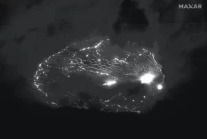
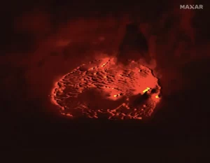
- Maxar Technologies’ WorldView-3 and WorldView-2 satellites captured stunning images of a Hawaiian volcanic eruption at night, showcasing the eerie beauty of lava.
- The eruption, which began on September 29 at Kīlauea volcano, featured lava spewing from two vents within Halema’uma’u crater, according to the United States Geological Survey (USGS).
- The images revealed a mesmerizing glow emanating from the volcano, with the eruption confined to the crater in Hawaii Volcanoes National Park.
- Authorities have been monitoring the eruption since its start, emphasizing that there is no immediate threat to populated areas.
- The satellites, WorldView-2 and WorldView-3, have been orbiting in low Earth orbit since 2009 and 2014, respectively, capturing detailed imagery with impressive resolutions.
Mother Nature’s dramatic showcase of power and beauty has been captured in extraordinary detail by Maxar Technologies’ advanced satellites, WorldView-3 and WorldView-2, unveiling the striking volcanic eruption at Hawaii’s iconic Kīlauea volcano.
These high-resolution images, taken on consecutive days in late September and early October, offer a spellbinding glimpse of molten lava flowing from vents within the Halema’uma’u crater, illuminating the night sky with an ethereal glow.
The United States Geological Survey’s daily updates on the eruption describe the ongoing spew of lava from two vents within the crater, one situated along the floor and the other on its western wall. Despite the mesmerizing visuals, the agency alerts about heightened volcanic gas emissions, including water vapor, carbon dioxide, and sulfur dioxide. These emissions, upon contact with the atmosphere, pose multiple risks, from the creation of volcanic smog (vog) to potential health hazards for humans, livestock, and crops.
The captivating display of nature’s fury also carries risks beyond the immediate vicinity of the eruption. As volcanic gases disperse, they create vog, a visible haze that can extend far beyond the site, affecting air quality and posing health threats. Additionally, fine volcanic glass particles, causing skin and eye irritation, may travel with the wind, potentially impacting areas several hundred feet away.
Kīlauea, characterized as a shield volcano renowned for its gradual slopes and periodic eruptions, had experienced a relatively quiet phase until this recent volcanic activity commenced in late September. Despite the heightened volcanic activity, authorities reassure that populated areas face no immediate threat, emphasizing the significance of ongoing monitoring efforts to ensure public safety.
Maxar’s satellites, stationed in low Earth orbit, offer an unparalleled vantage point to capture these mesmerizing yet perilous events. Orbiting at altitudes of 480 and 383 miles respectively, WorldView-2 and WorldView-3 boast sun-synchronous orbits, maintaining consistent lighting conditions for their high-resolution imagery capturing capabilities.
These satellites employ advanced imaging technologies, including panchromatic and multispectral bands, enabling detailed monitoring of natural phenomena. With a revisit rate of once a day and impressive resolutions ranging from 1.5 to 12 feet, these images provide scientists and researchers with crucial data for in-depth analysis of volcanic activities, aiding in hazard assessment and disaster management.